Cova da Beira, Portugal
The Case study region
Cova da Beira is located in the interior east part of Portugal. It comprises 4 counties: Belmonte; Covilhã, Fundão and some parishes of Castelo Branco. In addition to some industry, the region has strong traditions in the agriculture and forestry sectors, and it is much known for its top-quality agriculture products.
The landscape at Cova da Beira is characterized by two main altitudinal zones: a large relatively flat valley at the centre, which is surrounded by mountain ranges. The flat area is composed by a mosaic of agricultural land uses, including pastures, cropland, and orchards, but also forest patches, including native oak forests and pine plantations.
The climate is warm. The winter months are more wet than the summer months. The climate here is classified as hot-summer Mediterranean climate (Csa by the Köppen-Geiger system). The average annual temperature is around 14 °C and the average yearly rainfall is 991 mm.


The Pilot
Cova da Beira region demo provides the conditions to demonstrate SILVANUS Phases A and C applied to the protection and management of two essential types of infrastructures : water and energy infrastructures. To contribute to the fire prevention phase the SILVANUS Portuguese pilot will integrate land use and agricultural management with digital technologies focused on remote and proximal sensing, including satellite and UAV imagery and IoT networks to implement monitoring and early warning systems to ensure that both natural values and human critical infrastructures are fully safeguarded in a cost effective way.
The Portuguese pilot encompasses both the Portuguese main electrical utility (EDP) and the main water utility (Águas de Portugal, AdP), one of the most reputed academic institutions(IST-ID, Instituto Superior Técnico) and a private farming company (Terraprima), which is a front runner in the implementation of farming 4.0.
EDP’s main activity involves all the energy vertical from generation to commercialization in exception of the High Voltage transport, which is managed by other company. EDP has many assets – lines, generation plants, transformers, buildings – which by being dispersed in the territory are exposed to fire risk and extreme weather natural disasters. In the project subregion, EDP has many assets which perform critical services and are often located in remote areas, such as the supply of electrical energy to isolated villages or houses.
AdP’s core activity involves the integrated management of the urban water cycle and spanning all of its respective stages, being responsible for the management of several thousand infrastructures including more than 150 WTP, 1 000 WWTP, and 2 500 water and wastewater pumping stations in Portugal.

Within the project subregion, several dozens of electrical and water utilities facilities are located in remote rural areas, thus being exposed to wildfires. which may jeopardize both the electric supply and access to water and/ or sanitation services to the population.
These assets isolation creates additional challenges to the implementation of wildfire preventive actions, such as regular vegetation management of fire-prone species.
In the central region of Portugal, many overhead electrical lines have suffered disruption caused from forest fires. So, firebreaks need to be maintained as safety corridors along power lines to avoid the risk of accidental ignitions reaching the tree canopy. Like in many other remote regions, multiple overhead electrical lines cross Cova da Beira, either medium-voltage (MV) or low-voltage (LV).

Due to their number and dispersed distribution, the regular effort of gathering, harmonising and processing data to continuously evaluate fire risk, and the implementation of fire preventive measures are time and resource consuming requiring innovative solutions supported by an automated system for independent risk evaluation and targeted management.
The maintenance of the safety corridors becomes an enormous task because of the vast extensions of land which require vegetation monitoring and maintenance. Thus, it is essential to develop and implement cost-efficient techniques to be applied both to increase efficiency and effectiveness in this process, to keep up with the planning and to reduce operational costs.

Figure: Overhead lines safety corridors
Phase A
Evaluation assessment
Phase A will produce monitoring solutions and products to describe and evaluate land cover and wildfire risk at high spatial and temporal resolutions, meeting stakeholder information needs.
The integration of remote and proximal sensing data in modelling approaches, will be explored to deliver solutions for the detection and monitoring of natural vegetation growth and wildfire risk in the vicinity of critical assets to guide preventive management. The solution will include the generation of early warnings for fire risk based in multiple combined inputs, such as biomass growth, climate conditions, land use, citizens behaviour, among others.
Phase C
Restoration and rehabilitation of natural resources within burnt area
For the restoration and rehabilitation services, the Portuguese pilot proposes are focused on the evaluation of the potential of natural grazing with livestock to regulate vegetation structure and fuel loads, while restoring the diversity of plant communities, soil organic matter content and fertility, and ultimately contributing to forest resilience and resistance to environmental pressures and change.
Pilot Implementation
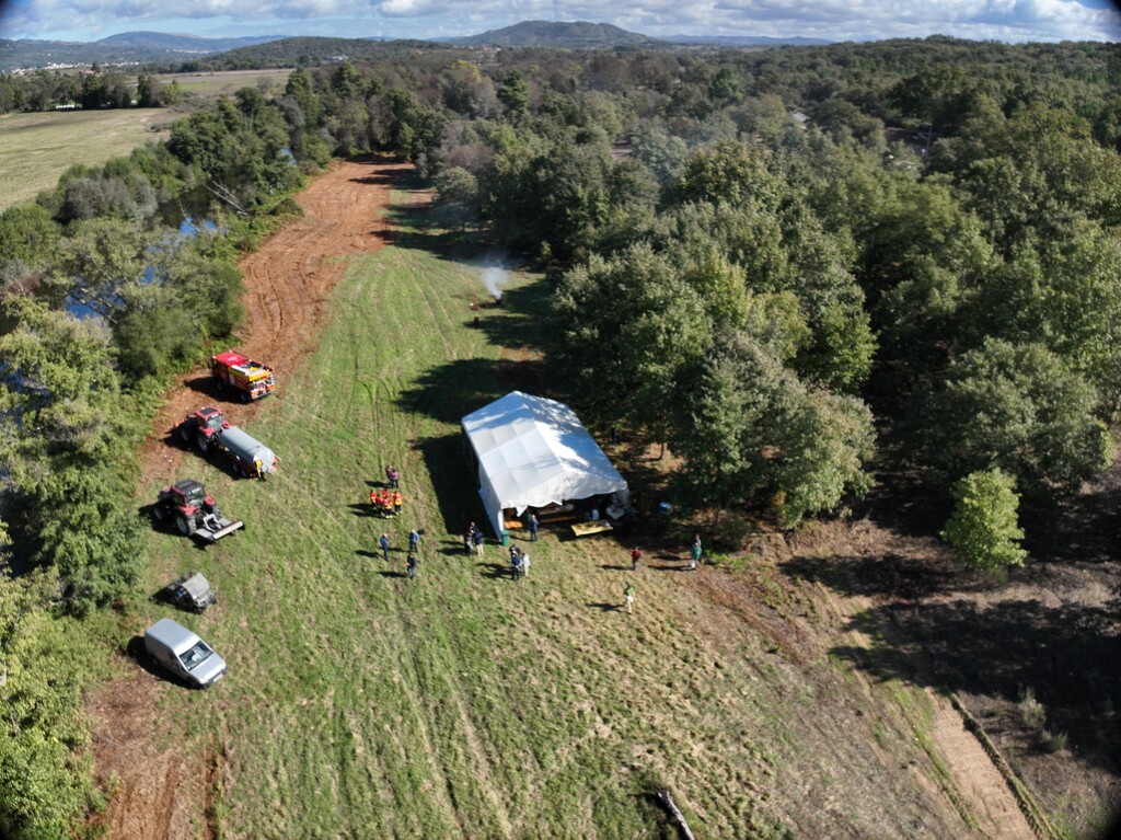
The SILVANUS team has convened in the fertile Cova da Beira valley in Covilhã in Central Portugal on October 9th, 2024 to test the platform in front of a wide audience of stakeholders. Organised by Portuguese partners EDP, Terraprima and IST-ID, Portuguese pilot also provides a general overview of the impact of wildfires on electricity and water infrastructure.
The site was at the Quinta da França in Covilhã, a property managed by Terraprima.
The pilot itinerary was divided into a workshop, where the components were demonstrated, and the exercise that featured a fire simulation and technology deployment. A special emphasis was given to showcasing the following components:
- Fire Danger Index
- Fire Detection based on Social Sensing
- Fire Detection from IoT Devices
- Drone Monitoring of Wildfire Behaviour
- Fire Detection at the Edge using Drone Data
- SILVANUS Citizen Engagement App
- Health Impact Assessment
- Evacuation Route Planning
- Ecological Resilience Index
- Biodiversity Index Calculation
- Continuous Monitoring of Rehabilitation Strategy Index
- Integrated Data Insights
- Forward Command Centre
- Platform Dashboard
The pilot was previewed by a classroom session at the Wool Museum, a location strongly connected to the theme of fire. This connection stems not only from the impact of livestock grazing on ecosystems but also from wool’s unique properties, including its resistance to fire up to 560°C, making it an excellent natural fire retardant. During the session, the present UPS (Unidades de Prevenção e Segurança) were introduced, alongside talks by key speakers on nature-based solutions and the use of prescribed fire as a tool for fire prevention and control. The session concluded with a tour of the Wool Museum, renowned for its rich industrial heritage.
The programme finished with an insightful session on the use of grazing as a land restoration strategy on the farm. This was followed by a guided tour of areas where cattle grazing is implemented for fire mitigation, as well as areas where prescribed fire is used as a preventive measure against wildfires.